")


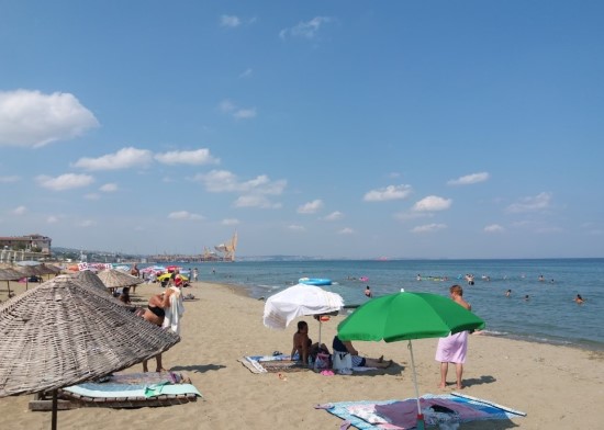
Considering average temperatures and general humidity indices, the climate of Tekirdağ province is characterized as temperate semi-humid. As one moves inland from the coastal areas, slight variations in temperature and precipitation are observed due to the influence of distance from the sea and altitude. Along the Marmara Sea coast, characteristics of the Mediterranean climate are seen, with hot and dry summers and mild and rainy winters. However, the influence of the Black Sea climate mitigates summer drought. Snowfall is common in winter. As one moves inland, semi-continental climate characteristics become more pronounced, with drier summers and colder winters.
Heat
According to 40 years of observations, the average temperature in Tekirdag in January is 4.4°C, in July it is 23.3°C, and the annual average temperature is 13.8°C. These values apply to the coastal strip stretching from the Tekirdag city center and the Istanbul provincial border to Sarkoy. As you move inland, temperature decreases of 1-2°C are observed due to the influence of continental climate and cold air masses from the Balkans during winter, and up to 3-4°C in the Ganos Mountains due to altitude. Annual temperature differences reach 19°C in the coastal areas and 20°C in the inland areas. Located between higher hills in the west and lower hills in the east, relative to the 200-300 meter ridges to the north, the city center recorded its highest extreme temperatures of 37.6 °C in July 1940 and 37.5 °C in August 1994, while the lowest extreme temperatures were measured at -13.5 °C in January 1942.
Pressure and Winds
In Turkey, changes in pressure systems and the resulting wind directions during winter and summer seasons also affect Tekirdag. During winter, migratory depressions (low pressure systems) coming from the west are influential. Furthermore, the interior regions of Anatolia are high-pressure areas, while the coastal areas are low-pressure areas. According to observations made between 1970 and 1997, the average pressure in Tekirdag in January is 1019.5 millibars, which is lower than the national average. Therefore, due to the influence of migratory depressions and local air currents, warm and cold fronts frequently shift, causing precipitation in the region. In summer, the influence of tropical pressure centers affecting Turkiye leads to a hot and dry period. However, due to air currents from the Azores high-pressure area to the Basra low-pressure area, cool and rainy days are also experienced from time to time. The average pressure in Tekirdag in July is 1012 millibars, and the annual average pressure is 1015.7 millibars.
Seasonal pressure changes cause shifts in wind direction. In the city center, the prevailing wind direction is northeast (poyraz), while the strongest wind direction is north (yildiz). During winter, snowfall is sometimes observed due to the influence of a cold front entering from the Balkans. During this period, the wind blows from the north and northeast. When a warm front from the Central Mediterranean is effective, the southwest wind (lodos) blows. The southwest wind, which can reach inland areas by channeling through the Meric valley, blows more frequently but for shorter periods along the coast, causing precipitation. Winds decrease in speed in spring and continue to blow from the north and northeast in summer. From September to December, the northwest wind (karayel) blows. 81% of the winds in Tekirdag have a speed of less than 6 m/s. The percentage of winds with speeds between 6-12 m/s is 17%. These percentages indicate that the winds in the region do not have a negative impact on plant and animal life.
Moisture
The average annual relative humidity in Tekirdag is 76%. While the average relative humidity increases in winter, it decreases in summer. In November, December, and January, the relative humidity is above 80%. During these months, the air's capacity to carry water vapor is low due to lower temperatures, making it easier for it to reach saturation. Coastal areas have lower relative humidity in winter. This is because temperatures are higher in coastal areas compared to inland regions.
Cloudiness
In Tekirdag, cloud cover values show a regular rise and fall, similar to the rainfall regime, which changes during the warmest and coldest months. In winter, cloud cover is high in Tekirdag and its surroundings due to the influence of the sea. The average cloud cover in January is 7.4. The average values for the other winter months, December and February, are almost the same. Cloud cover is low in summer. The average cloud cover in July is 2.2. The Tekir Mountains and Koru Mountains are also often cloudy. The clouds here are formed by sea and valley breezes. The temperature of the air rising from the seas and plains decreases, and its relative humidity increases. The annual average cloud cover in Tekirdag is 5.2.
Precipitation
According to the General Directorate of Meteorology's observation results and maps showing the annual and seasonal distribution of rainfall in Turkiye, the total rainfall in Tekirdag province varies between 200-300 mm in winter, 100-150 mm in spring, 50-100 mm in summer, and 150-200 mm in autumn. As for the average annual rainfall, the basin-shaped region in the center of the province receives 400-600 mm, while Koru Mountain, Tekir Mountain, and the Istranca Mountains receive around 800-1000 mm. This variation in rainfall values is a result of the topographical features of the region.
The long-term average annual rainfall in Tekirdag city center is 583.3 mm. Rainfall varies by month and year. The highest amount of rainfall is in December (average 86.2 mm), and the lowest is in August (average 11.8 mm). This information indicates that Tekirdag is dominated by the Mediterranean rainfall regime, with maximum rainfall occurring in winter and minimum rainfall in summer. Examining the distribution of rainy days throughout the year, the minimum is 2.2 days and the maximum is 12.6 days, with an average of 94 rainy days. 185 days of the year are cloudy, and 86 days are clear. Hail also occurs in some years. The highest number of hail days recorded was in 1963 (4 days), and the annual average is 0.8 days.
Regarding snow-covered days, there were none in some years (1934-1946). In contrast, it was recorded as 26 days in 1954. The average number of snowy days, generally starting in December and ending at the end of March, is 7.0 days annually, with 1.2 days in December, 2.8 days in January, 2.2 days in February, and 0.8 days in March.